Singapore's islands: Sentosa · Pulau Ubin · St John’s Island · Lazarus Island · Kusu Island · Sisters’ Islands · Pulau Hantu · Coney Island.
⚠️ Timetables, prices and access conditions may change without notice, for reasons beyond our control (season, weather, decisions by operators, venues or local authorities). Before every trip, check the information with the relevant authorities and service providers. Entry requirements and local rules (reserves, quotas) are subject to the same caveat.
Behind its skyscrapers and illuminated Supertrees, Singapore is above all an archipelago: one main island surrounded by some sixty islands and islets. Ten minutes by bumboat from Changi, Pulau Ubin still clings to village life, while to the south St John’s, Lazarus, Kusu and the Sisters’ Islands offer lagoons, corals and island temples. In the city, you can go in a single day from Chinatown's temples to the spices of Little India and the golden dome of Kampong Glam, with a meal at a UNESCO-listed hawker centre for a few dollars.
A city-state with some sixty islands
Singapore lies at the southern tip of the Malay Peninsula, separated from it by the narrow Strait of Johor, about 137 km north of the equator. The main island holds the city, but the state has some sixty islands and islets, many of which have been enlarged or joined together by land reclamation.
Three groups will interest travellers: Sentosa, a leisure island linked to the city by a boardwalk; Pulau Ubin, the last kampong (traditional village) in the north-east; and the Southern Islands (St John’s, Lazarus, Kusu, Sisters’ Islands), reached by ferry from Marina South Pier. We present them one by one below.
Sentosa, Pulau Ubin and the Southern Islands
Around the main island, a handful of islands are easy to visit on a day trip, by bumboat, by ferry or on foot across a bridge. Here are the ones worth the detour.
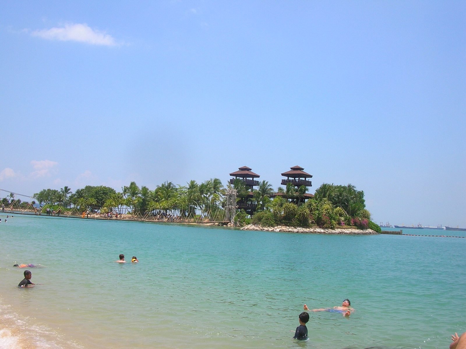
Sentosa — The largest and liveliest of Singapore's islands, linked to the city by a pedestrian boardwalk, a monorail and a cable car: three beaches (Siloso, Palawan, Tanjong), Fort Siloso, resorts, beach clubs and the theme parks of Resorts World. It now has its own guide on Dem-Tukki.
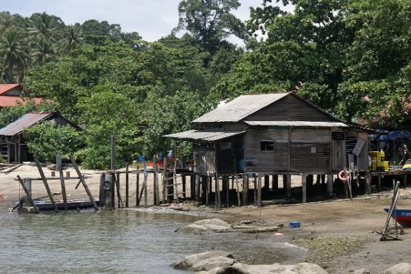
Pulau Ubin — Off Singapore's north-eastern corner, this boomerang-shaped island of just over 1,000 hectares was formed from five islets, joined together by the bunds of former prawn farms. Its granite, quarried from the 1840s, was used for Horsburgh Lighthouse, Fort Canning and the Causeway to Malaysia; the island had more than 2,000 inhabitants until the early 1970s, then emptied as the quarries closed, the last one shutting in 1999. Only about forty villagers remain, without running water or mains electricity, in kampongs of wooden houses that give an idea of 1960s Singapore. You explore it on foot or by bike hired in the village: to the east, the Chek Jawa Wetlands bring together beach, seagrass meadows, reef and mangrove along boardwalks and a 21 m observation tower (best seen at low tide), while Ketam Mountain Bike Park offers 10 km of trails around a former quarry. Bumboats leave from Changi Point Ferry Terminal, near Changi Village, from about 6am to 7pm, as soon as they have a dozen passengers: a 10-minute crossing for S$4 (S$2 extra per bike). After 6pm, it's best to arrange your return with a boatman. Camping is allowed at the Jelutong, Mamam and Endut Senin sites, only with an NParks permit requested at least two weeks in advance (there is a specific form for tourists).
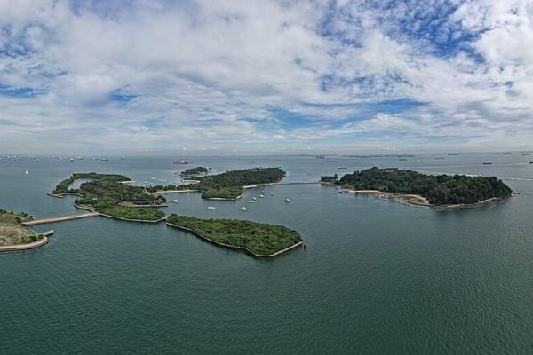
St John’s Island — About 6.5 km south of the city, this hilly island of some forty hectares is where Raffles's fleet dropped anchor the day before he landed in Singapore, in January 1819. After the cholera epidemic of 1873, it became a quarantine station in 1874, receiving Chinese immigrants and pilgrims returning from Mecca – up to 6,000 people in 1935 – before housing political detainees (1948-1959) and then a rehabilitation centre for opium smokers (1955-1975). The quarantine station closed in January 1976 and the island was converted into a leisure spot: swimming lagoons, beaches, picnic areas with barbecue pits, a nature trail, fishing from the shore and the NParks marine park's education gallery. You can stay overnight in the former bungalows and campsites managed by the Singapore Land Authority, to be booked at least 14 days ahead. Singapore Island Cruise and Marina South Ferries boats leave from Marina South Pier (about 25 minutes), but the main jetty has been closed for works since 24 April 2025: you land at Seringat jetty, half an hour's walk away. The authorities report the presence of box jellyfish: check before swimming. There are no shops or medical services on the island, so bring water and food.
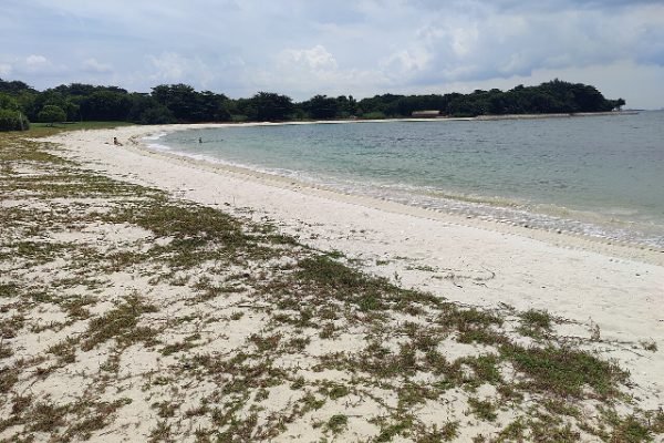
Lazarus Island — Linked to St John's by a causeway and joined to the islet of Seringat, the former Pulau Sakijang Pelepah ("island of the barking deer and palms") served as an ammunition depot and a hospital for beriberi patients in colonial times. Its long, curving beach, fringed with coconut palms and facing the city's towers, has made it Singaporeans' favourite seaside escape. In 2023, the island was redeveloped for low-impact tourism, with glamping (Into the Woods), small solar-powered cabins (Tiny Away), a container mini-mart open Friday to Sunday from 10am to 6pm and a non-motorised water sports centre. This three-year trial run by the Sentosa Development Corporation is coming to an end: Into the Woods operates until the first week of January 2027 and Tiny Away closes by February 2027, as their leases are not being renewed. Ferries from Marina South Pier drop passengers at Seringat jetty (S$15 return with Marina South Ferries) and the SLA also reports a regular service from Sentosa Cove; otherwise, you can walk to Lazarus from St John's in 15 to 20 minutes. Closed after the oil spill of June 2024, the beach reopened for swimming on 13 August 2024, and the south of the island is to become part of a future second marine park, "Lazarus South-Kusu Reef", announced in May 2024.
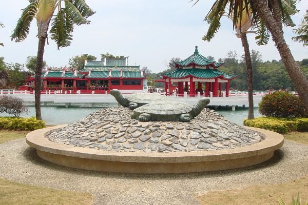
Kusu Island — 5.6 km south of Singapore, "Turtle Island" (Kusu in Hokkien) was just two rocks on a reef before being enlarged in 1975 to about 8.5 hectares. Legend has it that a giant turtle turned itself into an island to save two shipwrecked sailors, one Malay and one Chinese, who became a symbol of harmony between the communities. You can visit the Taoist Tua Pek Kong (Da Bo Gong) temple, built in 1923, with its turtle pond and "wishing tree", then climb 152 steps to the three keramat, Malay shrines where Chinese worshippers also pray; the rest of the time, the island offers lagoons and quiet picnics. The great pilgrimage takes place in the ninth lunar month, in 2026 from 10 October to 8 November: only Singapore Island Cruise ferries, leaving hourly from Marina South Pier between 7am and 5pm (S$16 on weekdays, S$18 at weekends), may dock during that time, and other public services only resume on 9 November. Camping and overnight stays are prohibited, and the bumboat jetty has been closed since 24 April 2025.
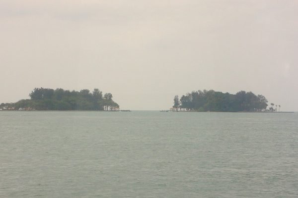
Sisters’ Islands — South of St John's, Big Sister's Island (Pulau Subar Laut) and Little Sister's Island (Pulau Subar Darat), separated by a narrow channel, owe their name, according to legend, to two drowned sisters who turned into islets. Since July 2014, together with the western reefs of St John's and Pulau Tekukor, they have formed the Sisters' Islands Marine Park, Singapore's first marine park, covering about 40 hectares. Little Sister, with its coral nursery and sea turtle hatchery, remains reserved for research, but Big Sister reopened to the public on 28 October 2024 after three years of works: the country's first floating pontoon, lagoons and tidal pools, a coastal trail to a lookout, and wildlife ranging from giant clams to bamboo sharks. The island is open from 7am to 7pm, except on the first and third Wednesdays of the month; camping, barbecues and fishing are prohibited, there are no lifeguards or shops, and NParks warns about lagoon currents and box jellyfish. Ferries leave from Marina South Pier (just over 30 minutes) with Singapore Island Cruise, which has suspended its weekday sailings until further notice and requires a change at Lazarus, or with Marina South Ferries. The free NParks guided walk, on the first Sunday of the month from 9.45am to 11am, is by registration only (30 places, 9am ferry at your own expense).
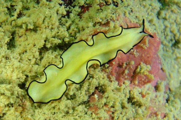
Pulau Hantu — West of the Southern Islands, close to the Pulau Bukom refineries, "Ghost Island" (hantu in Malay) comprises two islets, Hantu Besar and Hantu Kechil, covering about 12.6 hectares. Its name is said to come from a legend of Malay warriors killed in a duel, whose spirits haunt the place, or whom a djinn turned into two islets; more prosaically, the very low-lying central part disappears at high tide and seems to cut the island in two. The original reef flats have been partly reclaimed and breakwaters have created swimming lagoons, which you can wade across at low tide. Despite the nearby industry, its reefs are among the richest in Singapore, with abundant mushroom corals, clownfish, damselfish, wrasses and, sometimes, giant clams and seahorses. It is the go-to dive site for local clubs, but visibility, often limited to 1 or 2 metres, makes it mainly a spot for macro enthusiasts (nudibranchs). No regular ferry serves it: you need to charter a boat from West Coast Pier or Marina South Pier, and bring food and drink.
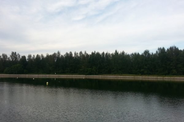
Coney Island (Pulau Serangoon) — In north-eastern Singapore, opposite the Punggol district, the former Pulau Serangoon belonged to the brothers Aw Boon Haw and Aw Boon Par before being sold in 1950 to a businessman who dreamed of creating a resort there inspired by Coney Island in New York – hence its name. Enlarged by land reclamation from 1975, it has been home since 10 October 2015 to an 81-hectare nature park managed by NParks, where the old Haw Par beach villa still stands, though entry is prohibited. A 2.4 km path crosses it through coastal forest, grassland and mangroves, leading to five beaches with different plantings and an estuary with giant mudskippers and tree-climbing crabs. More than 80 bird species have been recorded there, and a Brahman cow roamed free during the park's first year. You enter on foot or by bike via two bridges, to the west from the Punggol Point promenade and to the east near the Lorong Halus wetlands; the nearest MRT station is Punggol Coast, and there is no parking on the island. The park is open from 7am to 7pm; camping and fishing are prohibited, and NParks recommends long trousers and closed shoes against sandflies, as well as caution around monkeys, wild boar, stray dogs and box jellyfish.
Gardens, neighbourhoods and islands
In the city, the Supertrees of Gardens by the Bay, the UNESCO-listed Botanic Gardens, MacRitchie's suspension bridge over the primary forest and the Night Safari at Mandai reveal a far greener Singapore than you might imagine. Chinatown, Little India and Kampong Glam are best explored on foot, from temple to mosque.
On the island side, you can cycle around Pulau Ubin to the Chek Jawa boardwalks, dive at Pulau Hantu or head for Sentosa's beaches. The Sisters’ Islands marine park can be discovered on free NParks guided walks, with registration required.
Direct flights from Paris, then MRT and ferries
Air France and Singapore Airlines fly non-stop from Paris to Singapore in about 13 hours, and Singapore Airlines also serves Brussels. Once there, the MRT and buses can be paid for directly with a contactless bank card; Grab completes the network.
Bumboats from Changi Point cross to Pulau Ubin in ten minutes, and ferries from Marina South Pier serve the Southern Islands; as St John’s jetty is closed for works, you land at Seringat jetty (Lazarus). During the Kusu pilgrimage (until 8 November 2026), only Singapore Island Cruise ferries call there. Sentosa can be reached on foot, by monorail or by cable car from HarbourFront.
February to April
The climate is equatorial: 31 to 33 °C by day and 24 to 25 °C at night all year round. February to April is the driest period, February being the least rainy month. From November to January, the north-east monsoon brings the heaviest rain (December is the wettest month); for the rest of the year, afternoon thunderstorms are frequent but short.
Singapore at a glance
| Location | Southern tip of the Malay Peninsula, about 137 km north of the equator |
|---|---|
| Area | 745 km² (growing thanks to land reclamation) |
| Population | ≈ 6 million |
| Languages | English, Malay (national language), Mandarin and Tamil |
| Time difference | +7 hours from France in winter, +6 hours in summer |
| Currency | Singapore dollar (SGD) |
| Getting there | Direct flight Paris–Singapore (≈ 13 hours) |
| Entry requirements (French citizens) | Visa-free for up to 90 days; online SG Arrival Card compulsory |
| Electricity | 230 V, type G (British) plugs: adapter needed |
Your questions answered
Do French citizens need a visa?
No, for a tourist stay of up to 90 days. Your passport must be valid for six months after departure, and the free SG Arrival Card is completed online within the three days before arrival.
How do I get to Pulau Ubin?
Take the MRT to Tampines or Tanah Merah, then a bus to Changi Village (or a Grab), and finally a bumboat from Changi Point Ferry Terminal: a ten-minute crossing, leaving as soon as the boat is full. Then hire a bike in the village.
Can I visit the Southern Islands?
Yes, by ferry from Marina South Pier (25 to 35 minutes): Lazarus beach, the lagoons of St John’s and Big Sister's Island all make good day trips. There are no shops or emergency services on site: bring water and food, and check for box jellyfish warnings issued by the authorities before swimming.
What is the best season?
February to April, the driest period. It is hot all year round; from November to January, the monsoon brings more rain.
Header photo: The business district skyline at dusk — Basile Morin, CC BY-SA 4.0 / Wikimedia Commons
Island photos: Sentosa — Tdxiang, CC BY-SA 3.0; Pulau Ubin — alex.ch, CC BY 2.0; St John’s — Bob Tan, CC BY-SA 4.0; Lazarus — Denis Barthel, CC BY-SA 4.0; Kusu and Sisters’ Islands — Thaejas, CC BY 3.0; Pulau Hantu — yeowatzup, CC BY 2.0; Coney Island — Jianhui67, CC BY-SA 3.0 / Wikimedia Commons